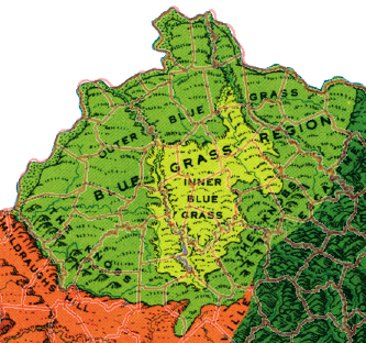
The Bluegrass physiographic region of Kentucky is located near the center of the state and is bordered by the Ohio River in the north and west and a ring of hills known as the Knobs in the west, south, and east. It is a rolling plateau that becomes more rugged near the edges. The underlying limestone is often visible at the surface in road cuts and where eroded by streams, most dramatically in the Kentucky River Palisades.
The region is named for Kentucky bluegrass (Poa pratensis), which has been extensively used in pastures here. The details of the introduction of bluegrass to the area are obscure, but it is probably of Eurasian origin and arrived in central Kentucky before the first European settlers.
The Bluegrass region was the most quickly settled part of the state and now is home to about half the state's population. The largest cities, including Louisville, Lexington, and the urban area of northern Kentucky are located here.
SEARCH THE KENTUCKY ATLAS & GAZETTEER
© 2026 David C. Elbon
